 |
Fossils
of Arizona
Photographic
Atlas - Main Page
|
|
Updated 8/29/21
 | This collection
of images of Arizona fossils is the result of decades of time
well spent in the field around our great State. We have spent
thousands of hours collecting, documenting and taking photos
of fossils covering a wide range of ages from Precambrian to
Holocene. In addition, countless of hours have been spent at
organizing, identifying (if possible) and properly storing and
labeling the specimens. Fossils that are too large or were not
removable have been extensively photographed in the field. Lets
start here now with Arizona's earliest fossils, from the Precambrian
limestones, cherts and shales of the Mescal Limestone in the
north central part of our State. |
Precambrian Strata:
Mescal Limestone.
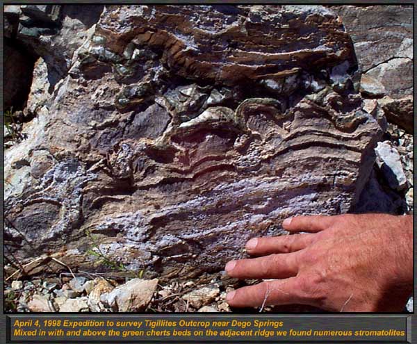 Click image to go to Write up.
| Synopsis:
The Mescal Limestone of Central Arizona and the base of the Mogollon
Rim contains locally abundant stromatolites and algal mats. Though
"stroms" are considered to be trace fossils, they represent
the remains of the largest life forms present 1.2 Billion years
ago in the Proterzoic Era. |
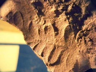
Cambrian Strata.
|
The Cambrian fossils
of Arizona occupy a special place in our hearts, the unique and
primitive lifeforms are our favorite members of our collections.
We have spent more time in the Cambrian than any other time period,
with the possible exception of the Mississippian Redwall Limestone.
The Tonto Group to the North and Cambrian in south eastern Arizona
are from the same ocean - but differ in naming and on some of
the fossil types found in each formation. To keep organized,
I will cover these formations separately, from the shallow tidal
flats of the Tapeats and Bolsa Quartzite, to the deep water limestones
of the Muav and Abrigo formation. Here is a listing of the Cambrian
formations we will be discussing here in Arizona:
Northern Arizona - Mogollon
Rim through to the Grand Canyon:
1. Tapeats Sandstone (Beach, tidal flat, shallow water)
2. Bright Angel Shale (Muddy sediments including deeper water shales, mudstones, claystones)
3. Muav Limestone (Deep water limestones)

South Eastern Arizona - South of Tucson to South eastern border.
4. Bolsa Quartzite (Beach, tidal flat, shallow water)
5. Abrigo Formation - Shale Member (Muddy sediments including deeper water shales, mudstones, claystones)
6. Abrigo Formation - Limestone Member (Deep water limestones)
|
 Click image to go to article
|
Synopsis: Tapeats of the Mogollon Rim / Payson / Grand Canyon
Area.
From the south limits
of the Town of Payson, to the East Fork of the Verde River north
of town, the Tapeats outcrops frequently and is the basal sedimentary
unit in the region overlaying the 1.8 billion year old Pre Cambrian
granites. In most areas it is less than 50 feet thick, and contains
a few sedimentary structures and strongly graded bedding which
highlights it origins - Near shore tidal flat and sand bar lithology.
We are quite familiar with this formation - Our house is right
on the outcrop! Fossils are very sparse and consist of primarily
trace fossils.
|
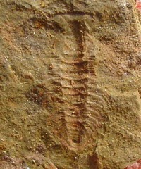 (Zacanthoides Trilobite)
Click image to go to article
(Zacanthoides Trilobite)
Click image to go to article
|
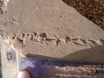
Synopsis: Bright Angel Shale of Northern Arizona.
Most paleontologist
are led to believe that the Lower Middle Cambrian Bright Angel
Shale can only be found in the depths of the Grand Canyon National
Park, and therefore is not open to collecting for the general
public. After much research spanning years pouring over old -
and nearly unobtainable geologic maps, professional papers and
Bulletins, we found that this is not the case. There are half
a dozen small areas far outside the Canyon (south), and isolated
outcrops in the Juniper Mountains in Northern Arizona. We spent
over a year finding and evaluating these outcrops - when accessible,
and found two in particular that were highly fossiliferous. Besides
hordes of Cambrian trace fossils, we found a plentiful but low
diversity of fauna similar to the Burgess Shale in British Columbia,
and the Chenchang Fauna in China. Phyllums include at least half
a dozen species of Trilobites, Hyalithids, inarticulate Brachiopods,
a colonial hydrozoan like animal, and trace fossils from arthropods,
mollusks, and annelids.
|
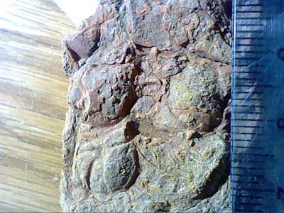 (Trilobite Cranidiums)
Click image to go to article
(Trilobite Cranidiums)
Click image to go to article
|
Synopsis: Abrigo Formation - Both members from South Eastern
Arizona
Starting with scattered
outcrops just south of Tucson and on the Southern ends of Gila
County, the Abrigo extends down to Arizona's border on its southern
most named extensions. Upper Middle Cambrian in age, this represents
a continuation in both extent and time for the northern Tonto
Group, but is present only in southern Arizona. Preservation
is similar to the Muav limestone and Bright Angel shale in the
Grand Canyon, but the exposed areas are more accessible as they
are visible in road cuts and in rolling hills. Fauna includes
many fragmentary trilobites, Hyalithids, inarticulate brachs,
trace fossils, a few rare echinoderms and peltmazoans.
|
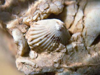
Devonian Strata:
Martin / Jerome Formation
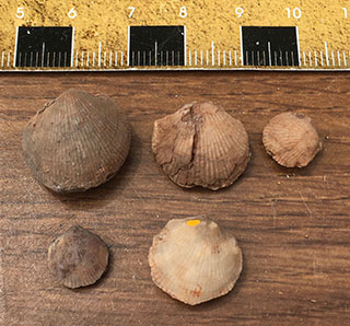 Devonian Invertebrates of the
Martin/Jerome Formation
Click image to go to Article
Devonian Invertebrates of the
Martin/Jerome Formation
Click image to go to Article
| Synopsis:
The Middle Devonian Martin Formation outcrops all over Arizona.
In the Payson area, it lies near the bottom of the Paleozoic
sequence sitting unconformably over the Cambrian Tapeats Sandstone.
In the Grand Canyon, the temporal equivelent is the Temple Butte
formation, and in south eastern Arizona it is called Martin Formation
also. The formations contain both marine and brackish water estuary
deposits, with invertebrates forming small isolated off-reef
commuities with a moderately low diversity of species. Brackish
water deposits contain Placoderm Arthrodire fish, while marine
communities include corals, sponges, stromatoporoids, brachiopods,
crinoids, trace fossils, and some interesting quartz and manganese
nodules formed on the ocean bottom. |
Permian Strata:
Fort Apache Limestone.
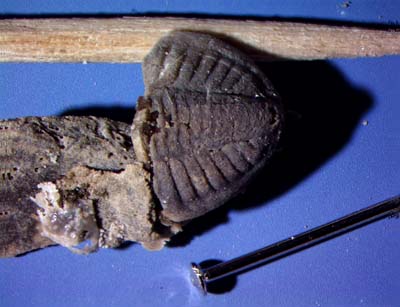 (Anisopyge inornata Trilobite)
Click image to go to Article
(Anisopyge inornata Trilobite)
Click image to go to Article
|
Synopsis: The
Fort Apache Limestone East of Payson, Az.
Leonardian in age, this
Permian marine transgression onto the Schnebly Hill formation
is a very thin facies with few if any fossils. However, the more
east you go towards the reservation in which it is at a maximum
thickness of 100 feet, the more fossils you will find. One location,
near the Highland Trail along Highway 260 is the last outcrop
available before it is under the surface on the Rim until the
reservation a hundred miles distant. There, you can find micro
fossils that can be retrieved by acid reduction of the limestones.
|
Paleo HOME
|